9 August 2014
- Kayak trip on the Bang Pakong River in East Thailand from Bang Taen in Ban Sang district until Hua Sai as part of the Bang Pakong River Kayak Route.
- Technical data
- We launched our kayaks at Wat Bang Taen on Ban Sang district in Prachinburi Province. We ended our first day on the Bang Pakong River at the Rainbow Arokayal Resort, were we stayed overnight.
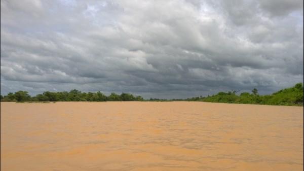
- The weather was partly cloudy with mostly sunshine. On some sections there were localized squalls that although not bringing rain, resulted in some headwinds on the westerly facing stretches of the river. Maximum temperature was around 29 C (Humidex: 33 C) with a SSW wind of 10 Km/Hr. Humidity was 75 % (Source: VTBS).
- Technical data of the trip was as follows: Total Distance: 28.84 Km; Moving Average: 6.7 Km/Hr; Overall Average: 6.3 Km/Hr; Maximum Speed: 9 Km/Hr; Moving time: 4 Hr 17 Min; Stopped Time: 19 Min; Total Time: 4 Hr 36 Min.
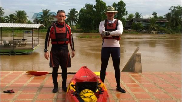
- Number of participants: 2 (Sean & Pat)
Patrick woke up at 04h00, it was still dark outside but he was excited about the new adventure awaiting. After packing his gear and loading his kayak, at 05h30 he, his wife and driver headed down to Ayutthaya to pick up Sean. It took about 20 minutes to fit the 2nd kayak on top of the roof of the pickup, all the while being passed by monks walking the street to collect Alms. At 06h20 we drove towards the Naresuan Bridge leaving Ayutthaya, it was partly cloudy and the sun shone brightly in the east; at least the weather looked promising. We took the Asia Highway then joined the Eastern Kanachanpisek highway before turning off at Lam Luk Ka and heading east. After a 2 ½ half hour drive, directed through the khlongs and paddy fields by Sean’s Google Maps, we arrived at Wat Bang Taen in Ban Sang district. Wat Bang Taen is situated on the Prachinburi River, shortly before its confluence with the Nakhon Nayok River forming the Bang Pakong River. We dismounted our kayaks and gear and started kitting up, it was shortly before 09h00 and the weather was fine and a bit cloudy, saving us from the scorching heat of the sun! Our first look at the Prachin Buri River revealed that is was flowing quite strongly and there was no problem with water hyacinth, excitedly we finished off preparing the kayaks and were in the water just after 9am, just south of the newly constructed suspension bridge.
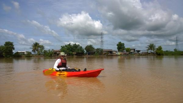
We eased into the start of the new trip, taking the customary photos and loosening up the paddling muscles, less than 10 minutes later we arrived at the confluence; the real start of our trip along the 122 kilometers long Bang Pakong River. The river here at its origin was already 130 meters wide and with the two rivers joining the current increased and we found ourselves paddling at a very comfortable 7 Km/Hr. We took some pictures at the confluence then set to the days task of paddling, the river banks were sparsely populated with only the occasional dwelling noticeable; the sky was partly cloudy and there were some dark sections in the distance. We occasionally heard the sound of thunder, but as we would determine later, this was just the sound of aircraft from the nearby International Airport; they would be audible for the whole length of the trip.
After the first hour we passed Wat Pak Khlong Bang Khanak (the monastery at the mouth of the Bang Khanak Canal) and the bridge over highway 3481, at this point we decided to take our first break (which we scheduled every hour) and sought refuge behind a floating pontoon beside what appeared to be a guest house. There were flags of various countries lining the river bank and Sean was proud to see that bizarrely, the South African flag flew the highest. With a barking pack of dogs watching us from the bank, we devoured our snacks and electrolytes in the shade of the floating pontoon. Rested we continued our paddling in a surrealistic environment of water and sky, the air was crisp and clear and felt good to breath. About 30 minutes later we faced the first test of the day, a stretch of river about 2 Km long that faced west. In the distance there were dark clouds that generated a wind directly up the river towards us creating steep uncomfortable waves in the middle of the river. Sean tried manfully to continue hoping to keep the speed of the current, however after taking a lot of water over the side and getting a soaked cockpit, he decided that it was prudent to join Patrick in the calmer water near the river bank!
Shortly before 1130 Hr near Wat Bang Rong we stopped for a second time in order to consume some food and water to keep our bodies functional in the by now hot and humid weather. After bang Krachet we noticed the first Nipa Palms (Nypa fruticans) along the river bank. The Nipa palm is a very useful palm, widely distributed in the mangrove forests of South and Southeast Asia as in Oceania. The leaves are traditionally used as roof materials, cigarette wrapper and medicine, while its sap is fermented to alcohol. Nipa, sometimes called the mangrove palm, has also a potential use as a bio-fuel crop. We loved it very much, because it gave us a permanent "on the beach" feeling.
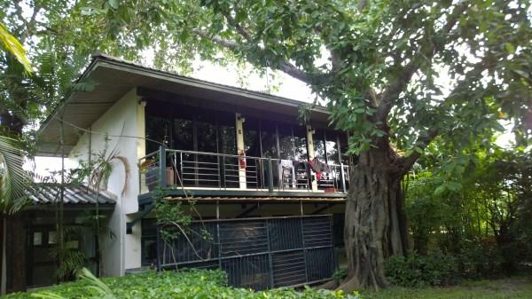
The rest of the morning was fairly uneventful, we passed the second bridge of the day at Wat Bang Krachet where we had a short discussion with some of the local people, a bit further up that stretch we also came across a strange sprawling resort, the Tarabangkla, with strangely designed buildings and some bemused guests who watched us paddle past. After that there were a few more rough westerly sections of river then shortly after 13h00 we reached the village of Hua Sai, thereafter we rounded the final bend of the day then started scanning the river bank for a sign of our destination, the Rainbow Arokayal Resort. It took a while and asking for direction from a helpful old man on the river bank, but we eventually spotted its two floating pavilions on the left bank. We paddled around a bit to find a landing spot and finally we arrived at the stairs of the resort at 13h40. We dragged out our kayaks and were met by the local staff, who was very surprised to find two boat people. It was the first time ever that people had arrived at the resort by kayak; maybe good for a mentioning in the Guinness Book of Records! We de-kitted our kayaks then tied them to a steel frame away from the river for security, thereafter we were shown to our rooms which were located on the second floor of a quiet section towards the back of the resort.
After freshen up after our 29 Km long trip, we had afternoon coffee in the parlor on the river, there we decided that as we had some spare time that afternoon, we would make a reconnaissance to the Bang Pakong Dam to check out if there would be any problems around the dam area for our kayaks the next day. The staff arranged a motorcycle tuk-tuk for us and down we went to Bang Kaeo district, to check on the dam. When we arrived we found that there would not be any problem at the dam as all the water gates were open and there was no steep drop as is the case on the Chao Phraya Dam. On the way back to the resort, we asked our motorbike pilot to pass over Bang Talat before driving back to the resort to visit the largest bronze Ganesha statue in the world, and very impressive it was! The standing Ganesha statue measures 39 meters and gazes over the Bang Pakong River. Construction started in 2009 and was finalized at the beginning of 2012. After taking a few pictures we enjoyed some really cheap Bht 5 coconuts before returning to our resort where we watched the sunset on the river before having dinner and a good night of sleep.